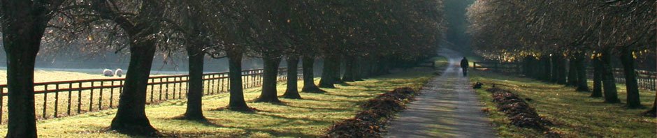

Photo I took at the Chicago Portage on one of my visits there, while conducting research for The Mystery at Black Partridge Woods. It gives a pretty good idea of what the area looked like in the early days—the early days being when American Indians and explorers traveled by canoe to Lake Michigan, and when they told Fr. Jacques Marquette about the route when he came this way in 1673.
My new book release, The Mystery at Black Partridge Woods, has a number of scenes where the characters travel through the Chicago Portage. It was this arrangement of bodies of water and ground level that was responsible for the City of Chicago. To understand its importance, you need to know the geography.

Thirteen thousand years ago, Lake Chicago was a pre-glacial lake. It later receded and left Lake Michigan. The curved line on the far right is the shoreline of today’s Lake Michigan.
The large “island” wedged where river meets the lake is Mount Forest Island. Today that island is Lemont, Palos, Willow Springs, and Cook County Forest Preserves, the western tip near the intersections of Route 83 and Archer Avenue. Two valleys formed on each side of the island, the Des Plaines River Valley on the north, the Sag Valley on the south. A good deal of both valleys, as well as much of the Chicago area, was swamp.
Rivers were used then like highways are today. The Des Plaines River runs south and west, beginning in Wisconsin and connecting to the Illinois River, and from there to the Mississippi and Gulf. The Chicago River ran parallel to the Des Plaines, but connected to Lake Michigan. These two rivers were only a few miles apart, and a low, swampy area connected them, becoming navigable after spring rains. This distance was a piece of cake! Men in those days were accustomed to carrying their canoes and belongings (portaging) over rough areas. This was just north of what is now Harlem Avenue and Route 55.
If Illinois was to be settled, people had to get from one place to another easily. How else to transport, for instance, a crop of corn? No sense growing it unless you could get it to a large population, right? No sense to have a farm, a village, a city, until transportation could be worked out. A port on Lake Michigan would connect the area to the east, but then what? No sense anyone coming to that port unless there was a population further west, and a way to get between the two.
It was this portage or low spot that connected the two rivers that was the reason for it all. Which is the reason the Illinois &Michigan Canal was built, to link the Great Lakes to the Gulf of Mexico. The reason the state line was drawn where it is rather than across the bottom of Lake Michigan as originally planned. The reason Chicago developed into a transportation hub and one of the largest cities in the U.S.
Some historians propose—look at the old map above again—that originally the plan was to travel through the swamp to the Calumet River and then to Lake Michigan. Indians lived here for many years, and they had developed a line of villages on Mount Forest Island overlooking the “Sag,” or swamp, that lay roughly where 107th Street is today. “Sag” is a geologic term that describes a persistent low area, opposite of a ridge or bluff. Some proponents thought that would be a better route for a canal, and perhaps it would have been. It is likely that politics came into play…
The Indians, and earliest travelers and maps, referred to all the rivers as Chicago, or Chi-ca-gou, or many other spellings of the Indian word. This universal name caused a great deal of confusion when historians tried to figure out what the explorers were referring to. There are also many meanings of the name; contrary to what is commonly believed, “stinking onion” is not the only meaning. In fact, the Potawatomi meaning is “desolate,” which the Chicago Portage still is today.
Let’s try to describe what the traveler taking this route would have encountered. He would have paddled his bark canoe (bark so the canoe was light enough to carry across tough spots) upriver from the southwest, and when he passed what is today Summit, Illinois he would have come to an area where the river turned straight north, where trees hugged the bank, penetrated by many inlets. He would come to a small stream, and making his way up it, to a wider area called Mud Lake. The water would be stagnant, maybe smelly, vegetation covered, with shallow spots, and he might have to get out of his canoe and pull it. There would have been mosquitoes, gnats, leeches, other “nasties.” Eventually he could go no further, and he would stop and unload his canoe, piling his possessions on the first solid land he could find. He could not drag the canoe for fear of destroying the fragile bark. Then he would carry everything, including the canoe, a mile and a half (if he was lucky, farther when the river was low) over open prairie to a fork of the Chicago River, where he could continue (downstream now) to Fort Dearborn and Lake Michigan.
The Chicago Portage is a National Historic Site and you should visit it. You can walk the trails and view the signage on your own. The Friends of the Portage have either a walk or a lecture the first Saturday of every month. They also have excellent websites and a wealth of historic materials that are well researched. Check these websites: http://drupal.library.cmu.edu/chicago/ and www.chicagoportage.org.
Go see it. You won’t be sorry. (Wear old shoes and bring bug spray!)